At about 23:11 UTC on December 1, 2020, the lander-ascender combination of China’s Chang’e 5 space probe successfully landed in the pre-selected area on the lunar surface after the stages of active deceleration, rapid adjustment, hovering to avoid obstacles, and slow descent. It became China’s third space probe to perform a soft landing on the lunar surface. After its successful landing, the lander will officially start working on the lunar surface for about two days under the control of Mission Control.
Compared to its predecessors, including the Chang’e 3 and Chang’e 4 space probes, Chang’e 5 has unprecedented requirements for the precision and flatness of the probe’s landing position: the landing area should have no excessively high bulges; no excessively deep pits; and the slope should also meet mission requirements. During the lunar landing, the probe hovered at 100 meters above the lunar surface and the 3-D laser imaging sensor provided precise 3-D images of the lunar landing area when hovering, selected the landing position for precision obstacle avoidance, and touched down to the north of the Mons Rumker in Oceanus Procellarum, also known as the Ocean of Storms, on the near side of the moon.
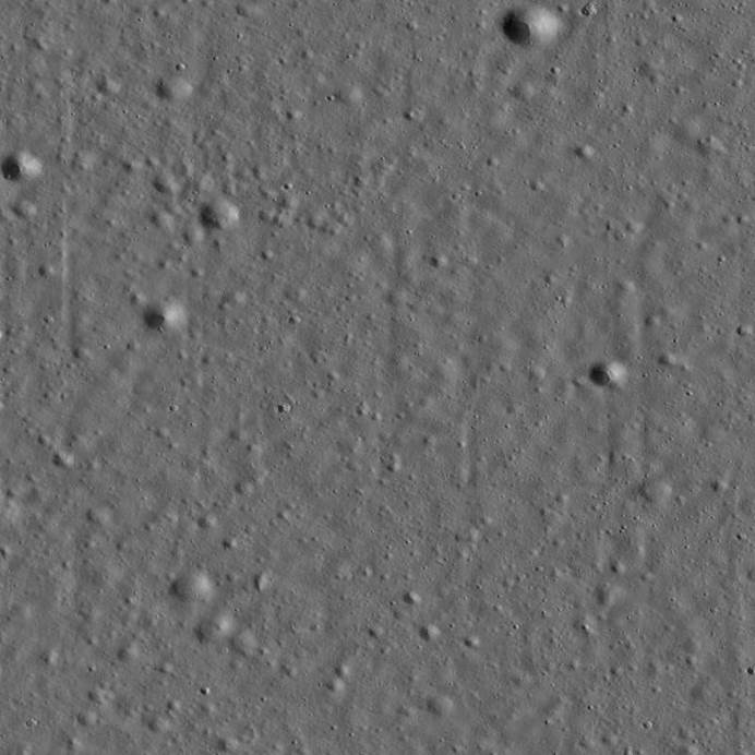
1.5-meter HD 3-D terrain near Chang’e 5 probe landing area
The successful soft landing of Chang’e 5 embodies the result of the wisdom and efforts of countless scientific researchers, including the important scientific and technological contributions of Tongji University’s Aerospace Surveying and Mapping, Remote Sensing, and Deep Space Exploration Research Team (hereinafter referred to as the “research team”).
The research team, led by Prof. TONG Xiaohua of the Surveying and Mapping discipline, comprises members from the Surveying and Mapping, Civil Engineering, Information, Physics, and other Tongji University disciplines. The team has undertaken Tongji University’s Key Basic Research Program. In addition, the team has also earned the honorary titles of Shanghai Education Pioneer and Advanced Collective of National Education System. The theoretical method of remote sensing spatial information credibility studied solely by the team for many years has broken through the difficult challenges of static element credibility measurement of space exploration scene, real-time dynamic data credibility processing of spacecraft, and credibility evaluation of massive remote sensing spatial data products, and has realized the quality improvement of 3-D laser remote sensing measurement. The technical approach provided important support for Chang’e 5’s 3-D laser imaging system to achieve measurement-level detection accuracy under extremely short imaging time conditions and to detect lunar rock and pit that threaten safe soft landing with high reliability.
For the landing obstacle avoidance mission of the Chang’e 5’s 3-D laser imaging system, the research team and the team of Shanghai Institute of Technical Physics of Chinese Academy of Sciences have cooperated for more than ten years to build a ground comprehensive experimental field for space laser payload calibration and obstacle detection verification (hereinafter referred to as the “experimental field”) at Tongji University. Additionally, they have completed more than 20 calibration and obstacle detection verification missions for the whole series of products of the 3-D laser imaging system for landing obstacle avoidance, such as the Chang’e 3, Chang’e 4, and Chang’e 5 probes, successively.
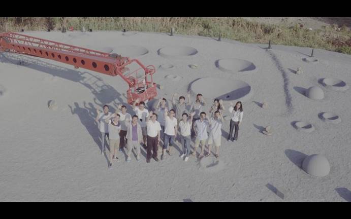
Prof. TONG mentioned that with the strong support of various departments and University leaders, Tongji University had built the Tongji University Surveying and Mapping, Remote Sensing and Navigation Positioning for Deep Space Exploration Sub-center of the Deep Space Exploration Joint Research Center of the Ministry of Education, and the Shanghai Key Laboratory for Space Surveying and Mapping, Remote Sensing and Space Exploration. The experimental field has been further upgraded to build a comprehensive one for precision surveying and mapping of the Moon and deep space exploration, covering an area of more than 30,000 square meters. In the future, the experimental field will continue to serve the follow-up Chang’e project and provide support for China’s research on Lunar South Pole, Mars, and Asteroid exploration programs.
Source: https://news.tongji.edu.cn/info/1003/75947.htm